Watch our short primer on how contrails affect the climate, and what we can do about it.


Contrails form in jet engine exhaust where heat, water vapor and black carbon (soot) mix with the ambient atmosphere.
Soot particles and other aerosols act as surfaces onto which exhaust water vapor condenses, forming liquid water droplets. The exhaust plume sinks down and away from the aircraft due to the wake vortex.
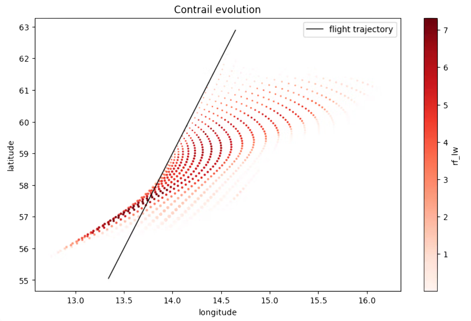
The plume is diluted by ambient air, which cools the plume and freezes liquid droplets into ice particles. Persistent contrails can last hours and grow to become indistinguishable from natural cirrus clouds.
Contrails form in jet engine exhaust where heat, water vapor and black carbon (soot) mix with the ambient atmosphere.
Soot particles and other aerosols act as surfaces onto which exhaust water vapor condenses, forming liquid water droplets. The exhaust plume sinks down and away from the aircraft due to the wake vortex.
The plume is diluted by ambient air, which cools the plume and freezes liquid droplets into ice particles. Persistent contrails can last hours and grow to become indistinguishable from natural cirrus clouds.

Ice clouds, including natural and contrail-induced cirrus clouds, are better at trapping outgoing longwave (thermal) radiation emitted by the Earth than reflecting incoming shortwave (solar) radiation from the sun. This means that, in general, cirrus clouds trap more heat in the Earth's atmosphere than they reflect. These clouds continue to absorb outgoing radiation at night, even when there is no solar radiation to reflect.
The contrail impact on incoming and outgoing radiation is defined as the radiative forcing. Contrail radiative forcing depends on time of day, season, cloud cover, and albedo (reflectivity) of the surface of the earth.
In aggregate, contrails are strongly warming, increasing the overall heat stored in the Earth's atmosphere.
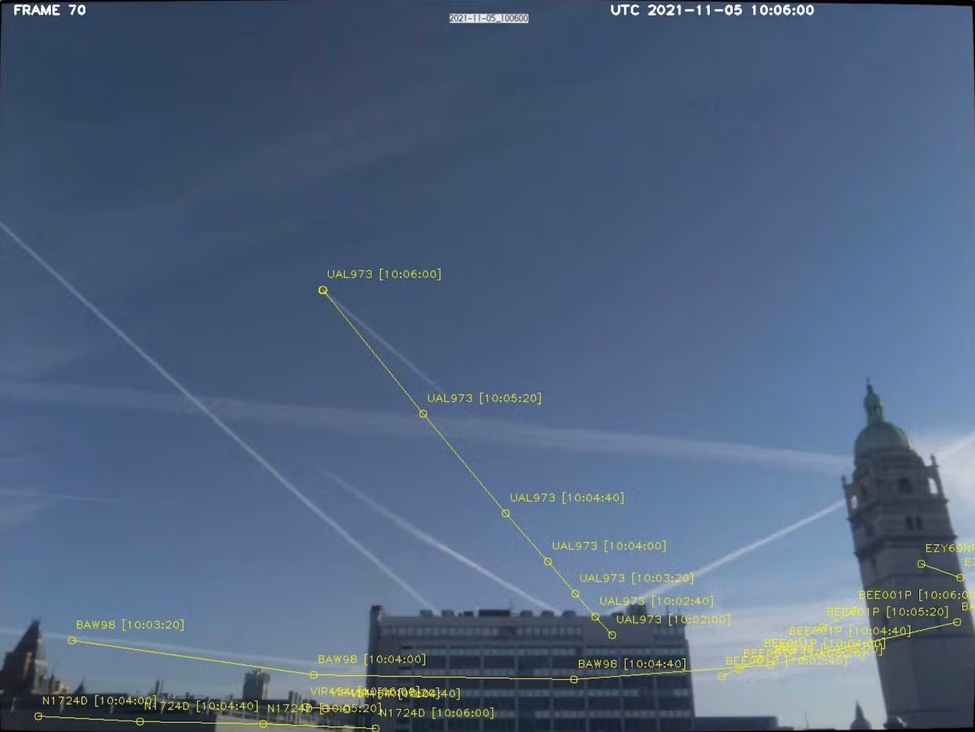
Persistent contrails form in thin regions of the atmosphere (500 - 1000m thick in altitude) that are sufficiently cold and humid. Forecasts can predict where airplanes are likely to form warming contrails and enable pilots to avoid these regions.
Unlike fleet-wide adoption of DAC and SAF, this approach has a low cost and logistical footprint.
Sustainable aviation fuel (SAF) is mostly biofuel produced from sustainable feedstocks used in place of traditional jet fuel. SAF has lower concentrations of aromatic compounds resulting in reduced soot emissions.
Studies of commercial flights using a blend of up to 50% SAF show a reduction of 50% to 70% in soot emissions. Contrails produced by planes burning a SAF blend show similar reductions in size and concentration of ice particles, decreasing their warming effect.
In 2024, only 0.3% of all aviation fuel was SAF. While SAF usage may increase in response to policies and regulations, it is expected to contribute to 2-5% of jet fuel in 2030.
The newest generation of jet engines burn fuel more cleanly and efficiently, resulting in large reductions in soot emissions.
Studies estimate that fleet-wide adoption of new engines could reduce contrail warming by as much as 70%.
These engines are currently being installed on new commercial airplanes, but will likely take decades to expand to the whole fleet.
With just minimal adjustments to only 5% of flight paths, we can eliminate 80% of contrails-induced warming.


The best available data indicates a kind of “super-Pareto principle” at play, where tweaking only a few flight paths would eliminate almost all of contrails-induced warming. In practice, this means that just 1 in 20 flights would need to fly over, under, or around areas of the sky predicted to produce harmful contrails.
Better yet, properly implemented, these adjustments would be cheap: Our studies show a fleet-average cost of roughly $20 per flight, or between $1–$2 per tonne of CO₂ equivalent warming avoided.

Weather forecasts, satellite images, flight locations, and other data are fed into contrail forecast models
Models determine where harmful contrails are likely to occur and compare these predictions with observations
Flight planners calculate the fastest route with the lowest fuel consumption accounting for contrail impact in their flight plan
Ground, air, and satellite observations verify contrail avoidance and feed back into forecasting models to improve data accuracy